Drone Archaeology: How UAV Technology Is Transforming Archaeological Surveys
Drone Archaeology How UAV Technology Is Transforming Archaeological Surveys
Introduction
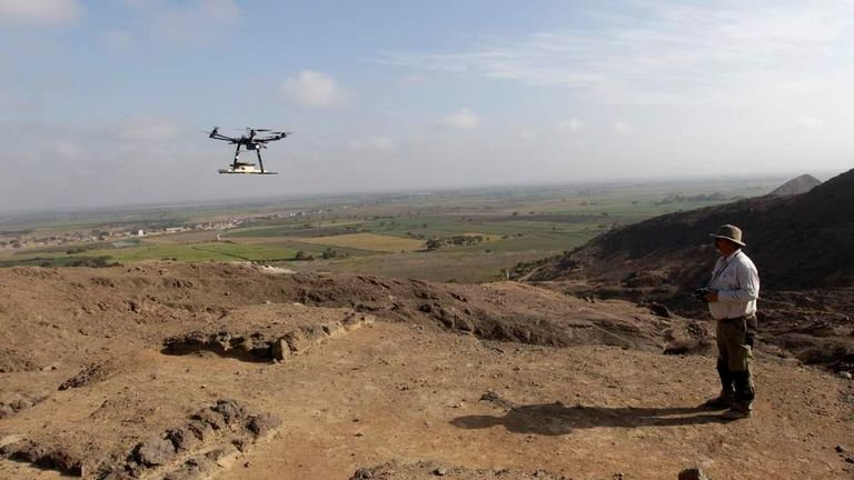
Drone Archaeology Services use unmanned aerial vehicles (UAVs) equipped with cameras and remote-sensing sensors to collect detailed spatrrounding landscapes. Archaeologists can use drone imagery, LiDAR, photogrammetry, multispectral sensors, and thermal cameras to map sites, document structures, analyze terrain, monitor changes, and create digital records. Drone As a Service supports these workflows by connecting aerial data capture with geospatial processing and professional deliverables.
Traditional archaeological fieldwork remains essential because archaeologists need direct observation, excavation, contextual analysis, and specialist interpretation. Drone technology adds an aerial perspective that can cover large areas efficiently and document locations that are difficult to access from the ground. A UAV survey can also create repeatable datasets for comparing site conditions over time.
This guide explains how drone archaeology surveys work, how LiDAR and photogrammetry reveal spatial information, what data products UAVs can produce, and how archaeologists can use those datasets with GIS and 3D modeling workflows.
Quick Answer: What are Drone Archaeology Services?
Drone Archaeology Services use UAVs equipped with cameras and remote-sensing sensors to capture aerial and spatial data for discovering, mapping, documenting, analyzing, and monitoring archaeological sites. The resulting datasets can include orthomosaics, point clouds, terrain models, 3D models, and GIS-compatible information.
Drone Archaeology applies UAV-based aerial imaging and remote sensing to archaeological research, site documentation, landscape analysis, and cultural heritage management. A drone carries a suitable sensor, follows a planned flight path, captures spatial observations, and transfers the resulting data to specialized processing software.
The approach connects several technologies:
UAV + sensor + positioning + data processing + GIS = archaeological spatial information
A conventional ground survey provides direct observations from selected locations. A drone survey provides a broader aerial perspective. These approaches work together rather than competing with each other.
For example, an archaeologist studying an ancient settlement may use a UAV to capture overlapping RGB photographs across the site. Photogrammetric software can reconstruct those images into a point cloud, orthomosaic, digital surface model, and textured 3D model.
A LiDAR survey can provide another type of evidence. Laser measurements can produce a point cloud that supports terrain modeling and analysis. In suitable environments, processed LiDAR data can make subtle ground features easier to identify.
Why Is Aerial Data Useful for Archaeology?
Aerial data can show relationships that are difficult to understand from ground level.
Resea
How Do Drone Archaeology Surveys Work?
A professional drone archaeology project follows a structured workflow. The survey team first defines the archaeological objective and then selects the appropriate UAV, sensor, positioning method, flight plan, and processing workflow.
1. Archaeological Site Assessment
The process starts with an assessment of the archaeological site.
Researchers VegetatioThe survey should therefore begin with the archaeological question rather than the sensorFlight planning determines how the UAV captures the site.
The survey team definesFlight altitudeImage overlapCamera orientatioA carefully planned mission produces more consistent source data and reduces unnecessary gaps in coverageThe UAV collects data using a sensor selected for the archaeological objectivRGB cameras capture visible-light imagery. Overlapping photographs can support photogrammetric reconstructionRuins.
- WallMonument structures.Archaeological landscapes.
LiDAR uses laser pulses to measure distances between the sensor and surround
A LiDAR-equipped UAV can produce dense three-dimensional point clouds. These datasets can support terrain analysis and feature identification, particularly in suitable vegetated environments.
Multispectral Sensors
Multispectral sensors capture selected wavelengths beyond standard RGB imagery.
Archaeologists can use spectral differences to investigate vegetation and landscape patterns that may relate to buried or historic features.
Thermal Cameras
Thermal sensors record differences in infrared radiation.
Thermal data may provide additional information about surface materials, moisture-related patterns, and structural differences under suitable environmental conditions.
Sensor performance depends on the site, weather, acquisition timing, sensor specifications, and processing methodology.
4. Georeferencing and Survey Control
Archaeological drone data needs a reliable spatial reference when researchers need accurate mapping or integration with other datasets.
GNSS
Global Navigation Satellite System (GNSS) technology provides positioning information for the UAV and survey control points.
RTK and PPK
RTK provides positioning corrections during data collection. PPK applies positioning corrections during post-processing.
Both approaches can improve georeferencing when properly configured and supported by the survey workflow.
Ground Control Points
Ground Control Points (GCPs) are accurately surveyed locations that appear in the drone imagery. Processing software can use their known coordinates to improve georeferencing and help validate the resulting model.
The appropriate control method depends on project requirements, equipment, terrain, and required accuracy.
5. Data Processing
Raw drone imagery or LiDAR measurements require processing before researchers can use them for archaeological analysis.
For photogrammetry, processing can include:
- Image alignment.
- Feature matching.
- Camera-position estimation.
- Point-cloud generation.
- Surface reconstruction.
- Orthomosaic generation.
- Digital model creation.
- 3D mesh generation.
LiDAR processing can include:
- Point-cloud generation.
- Georeferencing.
- Noise filtering.
- Ground classification.
- Terrain extraction.
- Feature analysis.
The processing workflow converts raw sensor observations into spatial datasets that archaeologists can inspect, measure, compare, and integrate with GIS.
6. Archaeological Interpretation
Processed drone data does not automatically prove the presence of an archaeological feature.
Archaeologists interpret spatial patterns alongside other evidence.
Drone-derived datasets can help researchers identify:
- Terrain anomalies.
- Possible structural remains.
- Earthworks.
- Ditches.
- Mounds.
- Embankments.
- Ancient pathways.
- Settlement patterns.
- Landscape relationships.
For example, a subtle linear elevation change may appear clearly in a terrain model. An archaeologist can compare that feature with historical maps, field observations, excavation records, and other spatial evidence.
This distinction matters: drone data provides evidence for investigation; archaeological expertise provides interpretation and context
How Do Drones Help Discover Hidden Archaeological Features?
Drone technology can help researchers identify archaeological features that are difficult to recognize from conventional aerial photographs or ground observation.
The technology does not literally allow a drone to “see through soil.” Instead, different sensors can reveal surface, vegetation, terrain, or thermal patterns that may indicate archaeological features.
Revealing Features Beneath Vegetation
LiDAR-derived terrain models can sometimes reveal subtle ground morphology beneath vegetation.
Dense vegetation can obscure archaeological earthworks from normal aerial imagery. LiDAR can record laser returns from different parts of the vegetation and ground surface. After processing and classification, researchers may be able to isolate ground points and create terrain models.
These models can expose subtle:
- Banks.
- Ditches.
- Mounds.
- Terraces.
- Ancient boundaries.
- Landscape modifications.
The effectiveness depends on vegetation density, sensor characteristics, point density, terrain, and processing quality.
Identifying Terrain Anomalies
Archaeological landscapes often contain small changes in elevation that may have historical significance.
A high-resolution terrain model can help researchers analyze:
- Earthworks.
- Ditches.
- Mounds.
- Embankments.
- Terraces.
- Ancient routes.
Aerial data does not determine the origin of an anomaly by itself. Archaeologists need additional evidence to establish whether a feature is archaeological, geological, agricultural, or modern.
Detecting Landscape Patterns
Drone surveys allow researchers to examine archaeological sites at landscape scale.
Instead of analyzing one wall or monument in isolation, researchers can examine relationships between:
Structures → terrain → pathways → vegetation → surrounding landscape
This broader spatial context can support landscape archaeology and help researchers develop hypotheses for further field investigation.
Drone LiDAR for Archaeology
Drone LiDAR has become an important tool for archaeological terrain analysis because it directly measures distances using laser pulses.
The sensor emits laser energy toward the ground and surrounding objects. Returned signals provide distance measurements that can be combined with positioning information to generate a three-dimensional point cloud.
Why Is LiDAR Valuable in Vegetated Archaeological Areas?
LiDAR can provide useful terrain information in vegetation where ordinary imagery may have difficulty distinguishing ground features.
A processed LiDAR dataset can separate different point classes, such as:
- Ground.
- Vegetation.
- Structures.
- Other objects.
Researchers can then create a Digital Terrain Model from suitable ground points.
The resulting terrain representation may make subtle archaeological morphology easier to examine.
LiDAR performance still depends on canopy density, sensor configuration, flight conditions, point density, terrain, and processing.
LiDAR Point Clouds and Archaeological Analysis
A LiDAR point cloud contains spatial points representing measured surfaces.
Archaeologists and GIS professionals can process these points to create:
- Raw point clouds.
- Classified point clouds.
- Digital Terrain Models.
- Digital Surface Models.
- Height grids.
- Hillshade visualizations.
- Contour data.
GIS analysis can then help researchers identify elevation patterns and relationships between archaeological features.
Photogrammetry in Archaeological Surveying
Drone photogrammetry creates three-dimensional information from overlapping aerial photographs.
The workflow commonly uses Structure from Motion (SfM) techniques to estimate camera positions and reconstruct spatial geometry.
The process generally follows:
Overlapping photographs → image alignment → feature matching → point cloud → 3D reconstruction → textured model
Photogrammetry can produce both visual and measurable spatial outputs when the survey is properly planned and controlled.
What Can Photogrammetry Document?
Drone photogrammetry can document:
- Ruins.
- Walls.
- Towers.
- Excavation areas.
- Monument structures.
- Archaeological objects.
- Surface features.
- Entire archaeological landscapes.
A textured 3D model can preserve the visual appearance of a site at a particular point in time. An orthomosaic can provide a georeferenced aerial representation for mapping and documentation.
Multispectral and Thermal Imaging for Archaeology
Multispectral and thermal sensors can provide information that standard RGB cameras cannot capture.
These technologies can complement rather than replace conventional archaeological imagery.
Multispectral Imaging
Multispectral cameras capture selected wavelength bands.
Researchers may examine spectral variations associated with:
- Vegetation patterns.
- Crop stress.
- Soil differences.
- Surface conditions.
- Landscape anomalies.
Vegetation can respond differently to variations in soil depth, moisture, and buried structures. These differences may create patterns that help researchers identify areas for further archaeological investigation.
The relationship is not automatic. Weather, plant species, season, soil, moisture, and agricultural activity can all influence spectral responses.
Thermal Imaging
Thermal cameras record infrared radiation and can identify differences in surface temperature.
Thermal imagery may provide additional information about:
- Surface materials.
- Moisture-related differences.
- Structural variations.
- Landscape patterns.
Acquisition timing matters. Solar heating, weather, surface material, moisture, and temperature conditions can significantly affect thermal observations.
Expert Note
Sensor performance and archaeological interpretation depend heavily on environmental conditions, acquisition timing, site characteristics, sensor specifications, and data quality. Researchers should treat multispectral and thermal patterns as evidence for investigation rather than definitive archaeological proof.
What Data Products Can Drone Archaeology Produce?
| Data Product | What It Provides | Archaeological Use |
|---|---|---|
| Orthomosaic | Georeferenced aerial imagery | Site documentation and mapping |
| Point Cloud | Three-dimensional spatial points | Structural and terrain analysis |
| DTM | Ground elevation | Landscape analysis |
| DSM | Surface elevation | Site visualization |
| 3D Mesh | Textured three-dimensional representation | Structures and objects |
| Height Grid | Elevation-based information | Terrain interpretation |
| CAD Data | Digital geometry | Documentation and planning |
| GIS Data | Spatially referenced datasets | Research and archaeological archives |
The appropriate deliverable depends on the research objective.
A heritage team may need an orthomosaic for documentation. A landscape archaeologist may need a DTM. A conservation team may need a detailed 3D model. A GIS professional may need spatial datasets that integrate with existing archaeological records.
Archaeological Applications of Drone Technology
Archaeological Site Mapping
Drone surveys can map archaeological sites and their surrounding landscapes from an aerial perspective.
Orthomosaics, point clouds, and terrain models can provide a spatial framework for identifying structures, boundaries, pathways, and other visible features.
Cultural Heritage Documentation
Cultural heritage teams can create detailed digital records of monuments, ruins, and historic structures.
A 3D model can document site geometry and surface condition at a specific point in time. Repeated surveys can create a record of physical changes.
Excavation Documentation
Archaeological excavations change rapidly as researchers remove and record layers.
Drone imagery can document excavation areas before, during, and after fieldwork. Orthomosaics and 3D models can complement traditional excavation records and photographs.
Landscape Archaeology
Landscape archaeology examines relationships between archaeological sites and their surrounding environments.
Drone data can support analysis of:
- Terrain.
- Elevation.
- Settlement patterns.
- Earthworks.
- Pathways.
- Agricultural features.
- Spatial relationships.
The aerial perspective helps researchers move from individual objects to broader landscape interpretation.
Monument and Ruin Documentation
Large ruins can be difficult to document completely from ground level.
A UAV can capture imagery from multiple angles and produce a detailed 3D representation of accessible exterior surfaces.
This can support:
- Condition documentation.
- Measurement.
- Visualization.
- Conservation planning.
- Digital archives.
Archaeological Site Monitoring
Repeated drone surveys can help organizations monitor site conditions.
Comparison between surveys can reveal changes caused by:
- Erosion.
- Vegetation growth.
- Construction.
- Natural events.
- Human activity.
- Structural deterioration.
This makes repeatable aerial documentation useful for long-term cultural heritage management.
Environmental Change Monitoring
Archaeological sites exist within changing landscapes.
Drone surveys can document changes in terrain, vegetation, drainage, and surrounding land use. Researchers can compare datasets from different periods to understand how environmental conditions affect archaeological resources.
Pre-Excavation Surveying
Before excavation begins, archaeologists can use UAV data to document the existing site.
Aerial datasets can help researchers:
- Define areas of interest.
- Identify visible anomalies.
- Understand terrain.
- Prioritize field investigation.
- Build a spatial baseline.
The results can inform field planning without replacing archaeological investigation.
Post-Excavation Documentation
After excavation, drone imagery and 3D models can preserve a digital record of the site.
These records can support:
- Research.
- Archiving.
- Publications.
- Site interpretation.
- Conservation.
- Future comparisons.
Drone Archaeology vs Traditional Archaeological Surveying
Drone technology provides a different perspective from ground-based archaeological survey methods. The strongest workflow combines both.
| Drone-Based Surveying | Traditional Field Survey |
|---|---|
| Provides large-area aerial coverage | Provides detailed ground observation |
| Captures aerial imagery and 3D datasets | Provides direct archaeological context |
| Supports rapid site documentation | Supports close-range investigation |
| Enables repeatable monitoring | Records physical observations |
| Helps survey difficult terrain | Enables direct inspection |
| Integrates with GIS workflows | Provides essential field context |
Drones should therefore be viewed as a complement to archaeological fieldwork, not a universal replacement for archaeologists.
A UAV can identify a possible earthwork. An archaeologist determines how that feature fits within the historical, environmental, and archaeological context.
What Are the Benefits of Drone Archaeology?
Non-Invasive Documentation
Drone surveys collect aerial information without requiring extensive physical contact with the site.
This can support documentation while reducing unnecessary movement across sensitive areas.
Large-Area Coverage
A UAV can capture imagery across large archaeological landscapes efficiently.
This makes aerial surveys useful for sites that extend beyond the practical coverage of a conventional walking survey.
High-Resolution Spatial Data
Modern sensors can produce detailed imagery and spatial datasets.
These datasets can support mapping, measurement, visualization, and GIS analysis.
3D Site Visualization
Photogrammetry and LiDAR can produce three-dimensional representations of archaeological environments.
Researchers can use these models to examine structures and terrain from different perspectives.
Repeatable Site Monitoring
Teams can repeat UAV surveys using consistent procedures.
Comparing datasets from different dates can reveal changes in archaeological site conditions.
Access to Difficult Terrain
UAVs can collect data over steep slopes, large landscapes, and areas where ground access is difficult.
This can reduce the need for unnecessary physical exposure to challenging terrain.
Reduced Need for Unnecessary Ground Disturbance
Aerial documentation can provide preliminary spatial information without requiring researchers to disturb archaeological deposits.
The approach supports non-invasive investigation, although archaeological interpretation may still require fieldwork or other approved methods.
Better Digital Archiving
3D models, orthomosaics, point clouds, and GIS datasets can create digital records of archaeological sites.
These records can support future research, conservation planning, education, and heritage management.
What Are the Limitations of Drone Archaeology?
Drone archaeology has clear benefits, but it also has technical, environmental, regulatory, and interpretive limitations.
Weather
Wind, rain, fog, and changing light can affect flight safety and data quality.
Vegetation Density
Dense vegetation can obscure ground features in imagery. LiDAR may help in suitable conditions, but sensor performance varies.
Flight Restrictions
Drone operations can be restricted by aviation regulations, protected areas, site rules, or local permissions.
Battery Limitations
Large sites may require multiple flights, batteries, or operational planning.
Sensor Limitations
Each sensor captures different information. RGB, LiDAR, thermal, and multispectral data cannot be treated as interchangeable.
Data Processing Requirements
Large imagery and point-cloud datasets require suitable hardware, software, storage, and technical expertise.
Ground Control Requirements
Projects with demanding positional requirements may need surveyed control points or other quality-control methods.
Interpretation Challenges
A visible anomaly does not automatically represent an archaeological feature. Natural terrain, agriculture, modern construction, vegetation, and erosion can create similar patterns.
Site Permissions
Archaeological and heritage sites can have specific access and documentation requirements.
Heritage Regulations
Drone operations may require permissions related to aviation, land ownership, cultural heritage, privacy, or protected sites. Requirements vary by jurisdiction.
Archaeological Expertise
UAV data requires archaeological interpretation. A technically accurate model can still lead to incorrect conclusions if researchers lack appropriate archaeological context.
Drone data should support archaeological interpretation and field investigation rather than being treated as definitive evidence by itself.
How Accurate Are Drone Archaeology Surveys?
Drone archaeology accuracy depends on the complete survey workflow rather than the UAV alone.
Important factors include:
- Sensor characteristics.
- Camera calibration.
- Flight altitude.
- Ground Sampling Distance.
- Image overlap.
- GNSS.
- RTK or PPK positioning.
- Ground Control Points.
- Terrain.
- Vegetation.
- Processing software.
- Quality assurance.
Factors That Improve Archaeological Mapping Accuracy
Plan the Survey Properly
The flight plan should match the required resolution, coverage, terrain, and final deliverables.
Maintain Adequate Image Overlap
Photogrammetric reconstruction requires sufficient common visual information between images.
Use Reliable Positioning
RTK, PPK, GNSS, and surveyed ground control can improve georeferencing when properly implemented.
Apply Ground Control
GCPs can help constrain and independently check the spatial accuracy of a photogrammetric model.
Maintain Consistent Processing
The processing workflow should use appropriate camera calibration, alignment, reconstruction, classification, and export settings.
Perform Independent Quality Checks
Check points, residuals, point-cloud inspection, and comparison with known survey information can help identify errors.
There is no universal accuracy value for every drone archaeology project. Accuracy should always be evaluated against the project’s archaeological, mapping, and documentation requirements.
How GIS Supports Drone Archaeology
GIS provides the spatial framework that connects drone-derived datasets with other archaeological information.
Researchers can integrate UAV data with:
- Historical maps.
- Satellite imagery.
- Existing DEMs.
- LiDAR datasets.
- Orthomosaics.
- Archaeological records.
- Excavation data.
- Survey observations.
This integration allows researchers to examine archaeological features within their broader landscape context.
GIS Analysis for Archaeological Landscapes
GIS can support:
- Terrain analysis.
- Elevation analysis.
- Slope analysis.
- Aspect analysis.
- Visibility analysis.
- Feature mapping.
- Spatial relationships.
- Landscape classification.
For example, a DTM generated from drone LiDAR archaeology can be combined with historical mapping to examine whether visible terrain features correspond with previously documented landscape elements.
How 3D Models Support Archaeological Research and Preservation
Drone-derived 3D models provide digital representations of archaeological sites, structures, and landscapes.
These models can support:
Digital Documentation
A 3D model can preserve the geometry and appearance of a site at a particular point in time.
Site Visualization
Researchers, students, heritage managers, and the public can view archaeological structures from different perspectives.
Structural Analysis
Detailed models can support examination of walls, ruins, monuments, and other exposed structures.
Historical Records
A digital model can become part of a long-term archaeological archive.
Virtual Interpretation
Three-dimensional datasets can support educational and virtual heritage experiences.
Conservation Planning
Repeated models can help conservation teams compare site conditions and document physical changes.
Before-and-After Comparison
Time-series models can provide evidence of erosion, deterioration, restoration, or environmental change.
Drone Archaeology Workflow: From Discovery to Digital Archive
A complete archaeological UAV workflow can be summarized as:
Research Objective → Site Assessment → Flight Planning → UAV Data Capture → GNSS/GCP Control → Processing → LiDAR/Photogrammetry Products → GIS Analysis → Archaeological Interpretation → Digital Documentation
Each stage contributes to the reliability of the final result.
The archaeological objective determines the survey design. The survey design determines the sensor and flight parameters. Positioning and control establish spatial reference. Processing converts raw observations into usable datasets. GIS connects those datasets with other archaeological information. Archaeological interpretation then places the results within historical and cultural context.
The final digital archive can contain imagery, point clouds, terrain models, 3D models, GIS layers, metadata, and survey documentation.
When Should Archaeologists Consider Drone Archaeology Services?
Drone Archaeology Services can be particularly useful when an archaeological project needs large-area aerial coverage, detailed documentation, repeat surveys, or GIS-compatible spatial data.
Consider UAV-based archaeological surveying when:
- A site covers a large area.
- Terrain makes ground access difficult.
- Vegetation limits conventional observation.
- Detailed aerial documentation is required.
- A 3D model is needed.
- Researchers need repeat surveys.
- Site preservation requires minimal disturbance.
- GIS-compatible spatial data is required.
- Researchers need terrain information.
- Existing archaeological records need updated spatial documentation.
The appropriate service depends on the archaeological question.
A site requiring detailed structural documentation may benefit from photogrammetry. A vegetated landscape may benefit from LiDAR. A project investigating vegetation-related patterns may consider multispectral imaging.
Drone As a Service can support organizations that need UAV-based data capture without building every component of an aerial surveying workflow internally. For archaeological projects, the workflow should still begin with research objectives, site requirements, permissions, and appropriate professional interpretation.
FAQs
What is drone archaeology?
Drone archaeology uses UAVs equipped with cameras or remote-sensing sensors to collect spatial information about archaeological sites and landscapes. Researchers can process this information into orthomosaics, point clouds, terrain models, 3D models, and other datasets for mapping, documentation, analysis, monitoring, and preservation.
What are Drone Archaeology Services?
Drone Archaeology Services provide professional UAV-based data collection and processing for archaeological research and heritage documentation. Services can include aerial photography, LiDAR, photogrammetry, georeferencing, 3D modeling, terrain mapping, and GIS-ready data production, depending on the project requirements.
How are drones used in archaeology?
Archaeologists use drones to map sites, document structures, survey landscapes, monitor changes, create 3D models, and identify potential terrain or vegetation anomalies. UAV data can complement ground surveys, historical records, excavation information, LiDAR datasets, and GIS analysis.
Can drones find archaeological sites?
Drones can help identify potential archaeological features by revealing spatial, terrain, vegetation, or thermal patterns. However, a drone image or model does not prove that an anomaly is archaeological. Archaeologists must compare the evidence with field observations, historical information, and other research data.
Can LiDAR drones detect archaeological features under vegetation?
LiDAR can sometimes reveal ground morphology beneath vegetation by recording laser returns from different surfaces. Processed ground points can support terrain models that expose subtle earthworks or other landscape features. Results depend on vegetation density, sensor characteristics, point density, terrain, and processing quality.
How does photogrammetry help archaeology?
Photogrammetry converts overlapping aerial photographs into spatial information such as point clouds, orthomosaics, 3D meshes, and textured models. Archaeologists can use these outputs to document ruins, excavation areas, monuments, structures, and archaeological landscapes.
What sensors are used for archaeological drone surveys?
Archaeological UAV surveys can use RGB cameras, LiDAR, multispectral sensors, and thermal cameras. RGB cameras support photogrammetry, LiDAR supports terrain and point-cloud analysis, while multispectral and thermal sensors can provide additional information about vegetation, surface conditions, and environmental patterns.
Can drones create 3D models of archaeological sites?
Yes. Overlapping aerial imagery can be processed through photogrammetry to create point clouds, meshes, and textured 3D models. LiDAR can also produce three-dimensional point clouds that support terrain and structural modeling.
Can drone data be used in GIS?
Yes. Drone-derived orthomosaics, point clouds, terrain models, elevation datasets, and other spatial products can integrate with GIS workflows. Archaeologists can combine these datasets with historical maps, satellite imagery, existing archaeological records, and other geospatial information.
Are drone surveys better than traditional archaeological surveys?
Drone surveys are not universally better than traditional field surveys. UAVs provide aerial coverage, spatial datasets, and repeatable documentation, while fieldwork provides direct observation, contextual interpretation, and physical investigation. Archaeological projects often benefit from combining both approaches.
What factors affect drone archaeology accuracy?
Accuracy depends on the sensor, flight altitude, ground sampling distance, image overlap, GNSS positioning, RTK or PPK, ground control points, terrain, vegetation, processing workflow, and quality assurance. The required accuracy should be defined according to the project’s archaeological and mapping objectives.
Final Takeaway
Drone Archaeology combines UAVs, remote sensing, positioning technology, photogrammetry, LiDAR, multispectral imaging, thermal imaging, and GIS to document and analyze archaeological sites. These technologies can provide detailed aerial imagery, point clouds, terrain models, orthomosaics, and 3D representations without requiring extensive physical disturbance.
LiDAR can support terrain analysis in suitable vegetated environments. Photogrammetry can reconstruct structures and landscapes from overlapping imagery. Multispectral and thermal sensors can add information about vegetation and surface conditions when environmental conditions support reliable interpretation.
The value of UAV technology depends on the entire workflow. Proper planning, sensor selection, positioning, processing, quality control, and archaeological interpretation determine how useful the resulting data becomes.
Archaeological teams looking for specialized Drone Archaeology Services can use UAV-based LiDAR, photogrammetry, multispectral imaging, and other aerial technologies to document sites and create detailed geospatial datasets.
Drone As a Service can help connect UAV data capture with professional geospatial workflows for archaeological documentation, mapping, 3D modeling, and site analysis. The strongest projects use drone technology as a complement to archaeological expertise, field investigation, and established heritage-preservation practices.