Austin construction photography
Austin continues to expand its road network to support steady growth and daily travel needs. The completion of Oak Hill Parkway and 183 North marks a major step forward in easing congestion and improving connectivity. Aerial imaging helps present these finished projects clearly. With Austin construction photography, viewers can better understand how these large road systems function in real conditions.
Oak Hill Parkway: What Aerial Views Reveal
Aerial views make it easier to understand how the Oak Hill Parkway project improves traffic flow and fits into its surroundings. From above, key features stand out clearly and help explain the design.
- Overpasses: Elevated sections that reduce stop-and-go traffic and improve movement
- Bypass Lanes: Dedicated routes that help drivers avoid congested intersections
- Intersections: Redesigned layouts that support smoother traffic patterns
- Surrounding Areas: Clear view of how the roadway connects with nearby neighborhoods and open spaces
These points show how aerial imagery simplifies complex road designs and helps viewers see real improvements without needing technical plans.
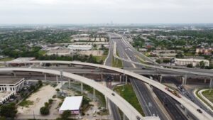
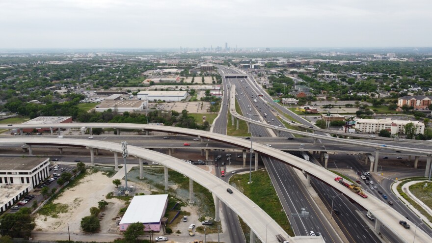
183 North Project: Capturing Scale from Above
The 183 North project covers a large stretch of highway in northwest Austin. It includes express lanes, updated interchanges, and shared-use paths. From the ground, it is hard to grasp the full size of this project. Aerial photography solves that problem by showing the full corridor in a single frame.
From above, the length of the roadway and the flow of traffic become clear. Drivers can better understand how the new lanes reduce delays and improve travel time. Aerial views also highlight how different parts of the road connect, giving a clear picture of how the project supports daily commuting across the region.
How Aerial Photography Documents Completion?
Aerial photography plays an important role in confirming that all parts of a project are complete and working as planned. It provides clear visual proof that supports both review and communication.
- Lane Markings: Final road lines and markings are clearly visible
- Road Signs: Placement and visibility of signs can be confirmed
- Surface Quality: Finished road surfaces can be checked for consistency
- Project Status: A complete visual record of the finished infrastructure
These details help teams and stakeholders review the outcome with confidence and ensure that nothing is overlooked.
Practical Uses of Aerial Imagery for These Projects
Aerial imagery serves several practical purposes once construction is complete. It helps present results clearly and directly to different audiences.
- Public Updates: Helps explain how the project improves daily travel
- Project Portfolios: Allows contractors to showcase completed work
- Marketing Use: Supports visual content for service promotion
- Stakeholder Communication: Provides clear visuals for reports and presentations
- Visual Proof: Reinforces results through Austin construction photography
These uses show how aerial images go beyond documentation to simply communicate value.
Conclusion
Aerial photography offers a clear way to view completed road projects and understand their real impact. For Oak Hill Parkway and 183 North, it highlights design, scale, and usability without confusion. These visuals support better communication and help people see the benefits of infrastructure upgrades. Overall, aerial imaging remains a practical tool for clearly showing completed work.